
Land Property Listing & Management Platform with Map Search and CRM Integration
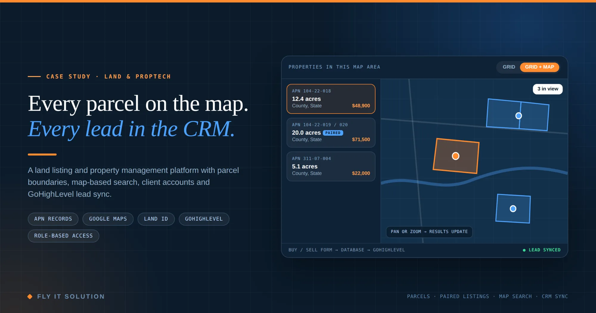
A US land sales company needed more than a property website. We built a full-stack platform where every parcel has its APN, boundary and map, buyers find land by moving a map, and every buy or sell enquiry lands in GoHighLevel without anyone retyping it.
Project Overview
- Industry
- Land sales, real estate, PropTech
- Client
- A US company that buys and sells land parcels
- Problem
- Listings, leads, client requests and content were spread across separate tools, and a standard real-estate site could not represent parcels, boundaries or grouped land properly.
- Services
- Full-stack web application development, role-based admin, lead management, CRM integration, mapping and parcel data, CMS
- Tech stack
- React · Lovable · Supabase · Google Maps JavaScript API · Land id embeds · YouTube embeds · GoHighLevel API
- Integrations
- GoHighLevel CRM, Google Maps, Land id
- Status
- Live in production
At a Glance
What we built into this project
The Challenge
Most property websites are built for houses. Land breaks them in four places.
A parcel is not an address
Rural land often has no street address. It is identified by its APN, county and state, and buyers want to see the actual boundary, not a pin dropped in the middle of a field.
A house-style listing template had nowhere to put that, so the details lived in descriptions and spreadsheets.
Some land is sold in pieces, some together
Adjoining parcels are often sold as one property at one price. Each parcel still has its own APN, acreage and boundary that the team must keep track of.
Listing them separately confused buyers. Merging them lost the parcel data.
Leads arrived from five forms into five places
Buyer enquiries, seller submissions and general questions came in through different forms. Someone had to copy them into the CRM by hand, and anything missed was a lost deal.
Buyers search land by region
People looking for land think in terms of an area on the map, not a dropdown of counties. A filter-only search made them guess where to look.
The Solution: From Parcel to Listing to Lead
We built one platform that holds the parcel data, shows it the way land buyers look for it, and moves every enquiry into the sales pipeline. Here is the path a property and a lead take through it.
How It Works
- 1
Staff create the parcel record
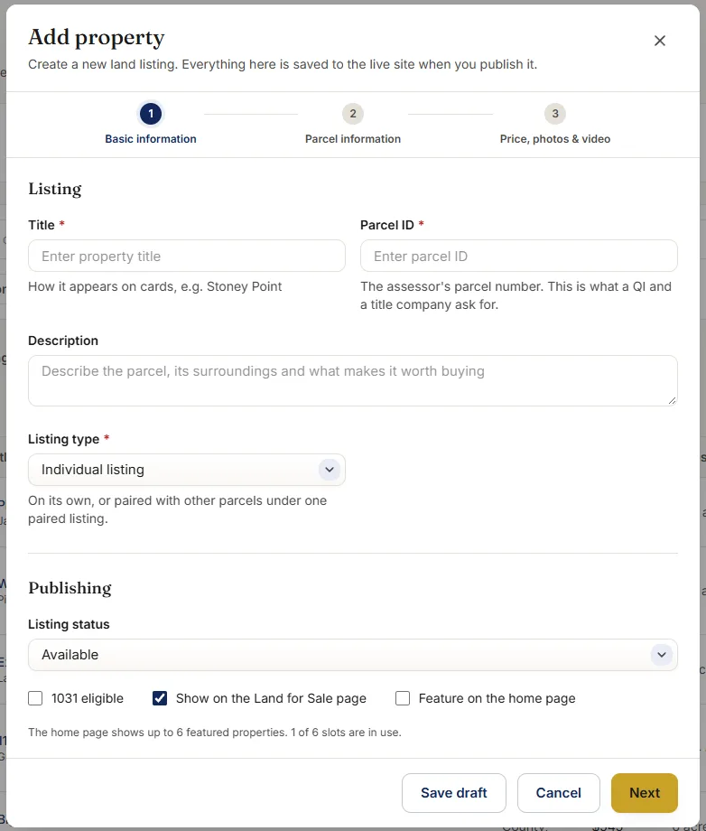
APN, state, county, acreage, photos, video, the Google Maps boundary and the Land id map, all in one form.
- 2
The parcel becomes a listing
On its own as an individual listing, or grouped with neighboring parcels as a paired listing with one price.
- 3
Buyers find it on the map
The grid and the map stay in sync; moving or zooming the map changes which properties are shown.
- 4
Buyers save it or ask for it
Logged-in clients add listings to a wishlist, or submit a property request describing what they want if nothing fits yet.
- 5
Every enquiry is captured once
All five website forms save to the platform's own database first, so no lead depends on a third-party service being up.
- 6
Buy and sell leads reach GoHighLevel
They are matched to existing contacts, tagged, and sellers get an opportunity in the pipeline with the property details already filled in.
Key Features & Modules
Role-based access for Admin, Staff and Client
Each role sees only what it needs. Admins manage users, settings and everything else; staff manage properties, leads and content; clients see their own account, wishlist and requests. Permissions are enforced on the server, not just hidden in the interface, so a client account cannot reach a staff screen by changing a URL.
Centralized lead management with GoHighLevel CRM integration
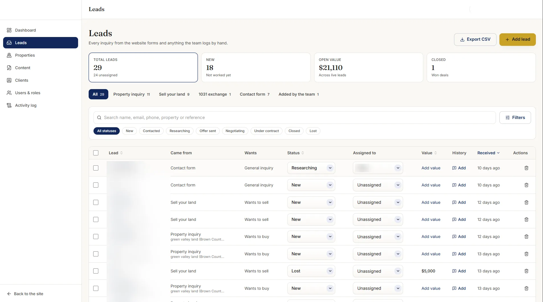
All five website forms feed one lead inbox inside the platform, where staff can see, filter and follow up on every enquiry. Buy and sell leads are also synced to GoHighLevel. Duplicates are matched by email or phone, leads are tagged by type, and seller leads open an opportunity with the asking price and parcel details. We wrote up how the sync works in our guide to website forms and GoHighLevel, and it is the same CRM integration pattern we use on other projects.
Property and parcel management
Every property is built around its parcel identity: APN, address where one exists, state, county and acreage. Each record also carries a photo gallery, YouTube video, the parcel boundary drawn on Google Maps, and an embedded Land id map so buyers can explore terrain and land data without leaving the listing.
Individual and paired property listings
A single parcel is published as an individual listing. Two or more parcels sold together are published as a paired listing with one title, one price and one page. Behind the paired listing, each parcel keeps its own APN, acreage and boundary, so the data stays correct if the parcels are later split and sold separately.
Client accounts, wishlists and property requests
Buyers can create an account, save properties to a wishlist and come back to them later. If nothing on the site matches, they submit a property request describing the land they want. Staff see those requests alongside the leads, which turns “nothing for me here” into a conversation.
CMS for blogs, press and announcements
Staff publish blog posts, press coverage and company announcements from the same admin they use for listings. No second website, no separate login, and content stays on the main domain where it helps search visibility.
Grid plus interactive map search
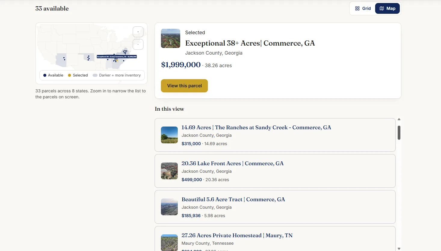
Buyers browse properties as a grid, a map, or both side by side. The map is the search. As the visitor pans or zooms across the US, the platform asks only for properties inside the visible area and updates the grid to match, so finding land in a region is as simple as moving the map there.
A Closer Look
Screenshots from the live product.
How We Built It
The guiding rule was that the parcel, not the listing, is the source of truth. Listings, maps, leads and requests all point back to it.
The parcel is its own record. Listings reference parcels rather than copy them. That is what lets a paired listing group several parcels without duplicating any data, and what stops the same APN being listed twice.
Search by map bounds, not by page. The map sends its current edges to the server, which returns only properties inside them. Results stay fast as the inventory grows, because the browser never loads the whole country.
Save the lead first, sync second. Every form writes to the platform's own database before anything else. The GoHighLevel sync runs on the server afterwards and retries if the CRM is unavailable, so a slow or failed API call never costs a lead.
Keys stay on the server. The GoHighLevel credentials never reach the browser. Visitors talk to the platform; only the server talks to the CRM.
Embed, do not rebuild. Land id already does detailed land mapping well, so we embed its maps on each listing rather than recreating that data, and draw our own boundary on Google Maps for search and overview.
Data Integrity & Access Control
A land business lives on accurate parcel data and on not losing leads. The platform protects both.
- Server-enforced role permissions for Admin, Staff and Client.
- One record per parcel, so APN, acreage and boundary cannot drift between listings.
- Every lead stored on the platform before it is sent anywhere, with a visible sync status.
- CRM credentials kept server-side only.
- Client accounts that see only their own wishlist and requests.
Results & Impact
- Leads from all five website forms now arrive in one inbox, and buy and sell leads reach GoHighLevel without manual entry.
- Every property carries its APN, county, acreage and boundary, so buyers and staff are always looking at the same parcel.
- Grouped land can be sold as one property without losing the individual parcel data behind it.
- Buyers browse land by region on the map instead of guessing at filters.
- The team publishes blogs, press and announcements from the same admin as their listings.
Services We Provided
- Full-stack custom web application development
- Role-based access control
- Property and parcel data modeling
- Google Maps and Land id integration
- Map-bounds search
- Lead management system
- GoHighLevel CRM integration
- Client portal
- Content management system
Who Built This
Fly IT Solution designed and built the platform end to end: data model, admin, client portal, map search, integrations and CMS.
We build custom software for US businesses from Minneapolis, Minnesota, with our development team in Mohali, India. Real estate and land platforms draw on the same things we do across our work: clean data models, CRM integrations and interfaces that non-technical teams use every day.
Client Feedback
Build a Modern Real Estate Property Listing & Marketing Platform
“Fantastic experience with Ankush. Underpromised and overdelivered- wish everyone worked like this :) Already mapping out how we continue to work together”
Land Listing Platform - FAQs
What should a land listing website have that a normal real estate site does not?
Land is sold by parcel, not by address, so a land listing site needs the parcel number (APN), county, state and acreage as first-class fields, a map that shows the actual parcel boundary rather than a pin, and the ability to sell several adjoining parcels together as one listing. Buyers also search land by area far more than by street, which is why map-based search matters more for land than for houses.
What is an APN and why does each listing need one?
An APN, or assessor's parcel number, is the number a county assessor uses to identify a parcel of land. Many rural parcels have no street address, so the APN together with the county and state is how a buyer, a title company or a surveyor confirms exactly which piece of land is for sale. Storing it as its own field also stops the same parcel from being listed twice.
How does map-based property search work?
The search reads the edges of the map the visitor is looking at and asks the server only for properties inside that area. When the visitor pans or zooms, the results grid updates to match. It turns search into browsing: instead of choosing a state and a county from dropdowns, a buyer moves the map to the region they care about and sees what is for sale there.
What is a paired property listing?
A paired listing groups two or more parcels that are sold together, such as adjoining lots, under one listing with one price, while each parcel keeps its own APN, acreage and boundary. The buyer sees a single property; the team still manages each parcel individually behind it.
Can website leads go straight into GoHighLevel?
Yes. On this platform every form submission is saved to the website's own database first, then buyer and seller leads are sent to GoHighLevel from the server, matched to an existing contact by email or phone, tagged, and given an opportunity in the pipeline for sellers. If GoHighLevel is unavailable, the lead is still saved and synced later, so nothing is lost.
Can Land id maps be shown on a property listing?
Yes. Land id lets a map or property tour be embedded on an external website, and this platform stores the Land id map for each parcel and shows it on the listing next to the Google Maps boundary, photos and video. Buyers get the detailed land data without leaving the listing.
Can Fly IT Solution build a land listing platform for my company?
Yes. We build custom listing and property management platforms for land and real estate businesses, including parcel records, map search, client portals, CMS and CRM integrations such as GoHighLevel. We work with US clients from Minneapolis, Minnesota, with our development team in Mohali, India.
Selling Land Online?
If your listings, leads and parcel data live in different places, we can bring them into one platform built for how land is actually bought and sold. Tell us how your team works today and we will show you what it could look like.
Ready to Start Your Project?
Let's discuss how we can help transform your business with our expertise
Send us a message
We respond within 24 hours
Quick Contact
Our Offices
Mohali
Cabin 1, E 279 (Biggbang), Industrial Area, Sector 75, Sahibzada Ajit Singh Nagar, Punjab 140307
Minneapolis
Unit B11, St Louis Park, MN 55426, United States
Moncton
Gordon Street, Moncton, NB E1C 5K9, Canada
Fast Response Guarantee
We respond to all inquiries within 24 hours. Most queries get a response within 2-4 hours during business hours.